
Which Raigad Land Does Atal Setu Actually Help?
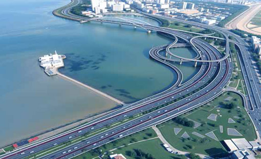
- Atal Setu (Sewri–Chirle, 21.8 km) is the one piece of Raigad-adjacent infrastructure that is fully built and already carrying traffic — the bridge crossed 2 crore (20,000,316) vehicles on 27 March 2026, an average of roughly 26,300 vehicles a day across its first 26 months, per MMRDA data reported by Free Press Journal.
- The car toll is ₹250 one-way / ₹375 return — a concessional rate fixed in 2024 at 50% of the ₹500 MMRDA had proposed, now extended for a second consecutive year, through 31 December 2026, by the Maharashtra Cabinet. Electric cars and buses pay nothing.
- Atal Setu’s direct, already-delivered shortcut is to the Uran–Pen–Alibaug–Shrivardhan side of Raigad via NH-66 from the Chirle interchange — route trackers put Mumbai-to-Alibaug at roughly 2 hours to 2 hours 15 minutes now, against 3 to 3.5 hours on the older Sion–Panvel route.
- Karjat and Khopoli are not on this route. They sit on the Mumbai–Pune Expressway / Samruddhi Mahamarg / Panvel–Karjat rail axis — infrastructure that is real and separately dated, but is not Atal Setu. Treating the bridge as a Karjat or Khopoli shortcut is the single most common mistake in how this story gets sold.
- The piece that would extend Atal Setu’s effect into Upper Alibaug itself — the Revas–Karanja bridge over Dharamtar Creek — is still under construction, targeted for around March 2028, and is expected to cut that crossing to about 30 minutes from over two hours today.
- This is a Decision post, not a Lookup one: it does not use “atal setu raigad land” as a reason to buy everywhere in Raigad — it tells you which part of that phrase the bridge has actually earned.
Is Atal Setu actually a reason to buy land in Raigad in 2026?
Yes, but only for the part of Raigad it physically connects to — the Uran, Pen, Alibaug and Shrivardhan side reached via NH-66 from the Chirle interchange, not the whole district, because the bridge is a delivered, tolled, two-year-old fact for that specific route and an unrelated one for Karjat or Khopoli.
Atal Setu is the only major piece of Mumbai 3.0 infrastructure touching Raigad that is fully finished, tolled, and carrying two years of measured traffic. That makes it the least speculative infrastructure story in the corridor — you’re not betting on a government resolution or a tender award, you’re reading traffic and toll data from a bridge that already opened on 13 January 2024. But “Atal Setu changed Raigad” is a headline, not a fact. The fact is narrower: it changed the drive from South Mumbai to the coastal Raigad talukas, and it has not, on its own, changed the drive to Karjat or Khopoli. A serious atal setu raigad land decision starts by knowing which half of that sentence applies to the specific plot you’re looking at.
What does the current data actually say — toll, traffic, travel time?
As of September 2026, Atal Setu carries roughly 26,300 vehicles a day on average, charges cars a concessional ₹250 one-way toll extended through 31 December 2026, and cuts the Sewri–Chirle crossing itself to about 20 minutes — the table below lists each figure with its own source and date.
MMRDA has run the bridge since its 13 January 2024 opening and publishes updates through its own project page and periodic data releases to the press. Here is what’s confirmed, with a source and date for each figure:
| Metric | Current figure | As of | Source |
|---|---|---|---|
| Route | Sewri (South Mumbai) → Chirle (Navi Mumbai/Uran), 21.8 km — 16.5 km sea, 5.5 km on land, 6 lanes | Live since 13 Jan 2024 | MMRDA project overview |
| Car toll | ₹250 one-way / ₹375 return (concessional; 50% of the ₹500 MMRDA-proposed rate) | Concession extended to 31 Dec 2026 | Maharashtra Cabinet decision, reported 17–20 Jan 2026 |
| EV toll | Fully exempt (cars and buses) | Cabinet decision, Jan 2026 | Free Press Journal |
| Total traffic | 2,00,00,316 vehicles crossed (2 crore) | 27 March 2026 (26 months from opening) | MMRDA data via Free Press Journal, published 29 Mar 2026 |
| Average daily traffic | ~26,300 vehicles/day | Calculated over the 26-month period to Mar 2026 | Free Press Journal |
| Sewri–Chirle crossing time | Cut from over an hour to roughly 20 minutes | Since opening | MMRDA overview / Free Press Journal |
Which part of Raigad does Atal Setu actually shorten?
Atal Setu’s proven shortcut runs south from Chirle along NH-66 through Pen toward Alibaug and Shrivardhan — it does not run east toward Karjat or Khopoli, which sit on the Mumbai–Pune Expressway and Panvel–Karjat rail axis instead, reached by a completely different road and rail network.
This is the distinction that matters most for a buyer, because “Atal Setu” and “Raigad” get used together in marketing copy as if the bridge touches the whole district equally. It doesn’t. Geographically, it can’t: the bridge lands at Chirle in Uran taluka, and NH-66 south from there is what actually reaches Pen, Alibaug and Shrivardhan. Karjat and Khopoli sit inland, off a different highway entirely.
| Uran / Pen / Alibaug / Shrivardhan (coastal Raigad) | Karjat / Khopoli (inland Raigad) | |
|---|---|---|
| Route from Mumbai | Sewri → Atal Setu → Chirle → NH-66 → Pen → Alibaug/Shrivardhan | Sion–Panvel → Mumbai–Pune Expressway (Missing Link since 1 May 2026) or Samruddhi Mahamarg, not via Atal Setu |
| Drive time now | ~2h–2h15m Mumbai–Alibaug (~95–100 km), down from ~3–3.5h on the old Sion–Panvel route, per independent route trackers | Khopoli via the Expressway Missing Link: ~25–30 min saved versus the old ghat section; Karjat via existing NH/rail links, largely unchanged by Atal Setu |
| Is Atal Setu the reason? | Yes — direct. This is the corridor the bridge was built to serve. | No — indirect at most. The driver here is the Expressway Missing Link, Samruddhi Mahamarg, and the Panvel–Karjat suburban rail line (99% built, targeted around Diwali 2026) — separate projects with their own timelines. |
| What’s still missing | The last-mile bridge into Upper Alibaug proper (Revas–Karanja, Dharamtar Creek) — under construction, targeted ~March 2028 | Confirmed local train start on Panvel–Karjat still awaited (Commissioner of Railway Safety clearance pending as of Sep 2026) |
The practical read: if you’re evaluating land near Alibaug or Shrivardhan, Atal Setu is a real, delivered, dated fact you can cite with confidence. If you’re evaluating land near Karjat or Khopoli, don’t cite Atal Setu — cite the Expressway Missing Link and the Panvel–Karjat rail line instead, because those are the projects actually doing the work on that side of the district.
What’s still under construction, not yet delivering
Two projects would meaningfully extend Atal Setu’s effect further into Raigad — the Revas–Karanja bridge over Dharamtar Creek, targeted for around March 2028, and the Virar–Alibaug Multimodal Corridor’s still-unfunded Alibaug-taluka leg — and neither is finished yet, so treat both as pipeline, not present tense.
The first is the Revas–Karanja bridge over Dharamtar Creek, a 2-km, four-lane structure being built by Afcons Infrastructure for MSRDC. It’s under active construction — pillar work in the creek is progressing, though approach-road land acquisition has caused delays — and is targeted for completion around March 2028. Once open, it’s expected to cut the Uran/Karanja-to-Alibaug crossing to roughly 30 minutes, against the current 70-km, 2-hour-plus road detour (a 15-minute ferry exists but doesn’t run through monsoon). The second is the Virar–Alibaug Multimodal Corridor, an eight-taluka, 126-km expressway that would eventually give the whole belt — including the Alibaug taluka stretch — a second high-capacity road link; its first phase (Navghar–Balavali) has administrative approval as of a Government Resolution reported in May 2026, but the phase that actually reaches Alibaug taluka does not yet have its own confirmed funding, so it’s a 2027-and-later story, not a 2026 one.
Neither of these takes anything away from what Atal Setu has already done. They’re the reason the Uran–Pen–Alibaug effect should keep strengthening rather than plateau, and the reason a buyer looking specifically at Upper Alibaug (versus Pen or the areas closer to Chirle) is buying slightly further ahead of delivered infrastructure than a buyer closer to the bridge itself.
Has the Atal Setu effect already been priced into land rates?
Partially, and unevenly — land closest to the Chirle/Pen side of the corridor has had over two years to absorb an operational bridge, while land further into Alibaug and Shrivardhan is still pricing in infrastructure (the Revas–Karanja bridge, VAMC Phase 2) that hasn’t been delivered.
This is LOTL’s read of the situation, not a verified market statistic, and we’re labeling it as analysis rather than fact: markets typically move on credible expectation of infrastructure before completion, then again on delivery, and Atal Setu has now had 26 months of delivery to be absorbed into asking prices along its immediate NH-66 corridor. That doesn’t mean the opportunity there is gone — it means the “Atal Setu opened, buy Raigad” pitch, on its own, is a 2024 argument being recycled in 2026. The more current argument is the combination: an operational bridge plus an operational airport (NMIA, domestic since 25 December 2025) plus two more links (Revas–Karanja, VAMC Phase 2) still to come. We are not making a return projection here — no figure in this section should be read as a promised or likely appreciation percentage; it’s a statement about which facts are settled and which are still pending.
How should a buyer read “Atal Setu” corridor by corridor?
Ask which of the two Raigad axes your plot sits on before you let “Atal Setu” do any persuading — because the answer decides whether the bridge is even the relevant infrastructure fact, and the coastal NH-66 side the bridge actually serves and the Karjat/Khopoli side served by the Expressway and rail line instead need two different checklists.
In practice:
- On the NH-66/Pen/Alibaug/Shrivardhan side: Atal Setu is a delivered, dated, verifiable fact. Confirm the plot’s actual road distance and drive time from the Chirle interchange (not just “near Alibaug”), and separately track the Revas–Karanja bridge and VAMC Phase 2 as the next two triggers still to come.
- On the Karjat/Khopoli side: don’t accept Atal Setu as the pitch. Ask instead about the Mumbai–Pune Expressway Missing Link (operational for light vehicles since 1 May 2026) and the Panvel–Karjat suburban rail line’s actual commissioning date — those are the infrastructure facts that apply to that side of the district.
- Everywhere: a seller citing “Atal Setu” for a plot that isn’t on NH-66 from Chirle is using a real project to make an irrelevant claim. That’s worth catching before you pay for it.
Illustrative example — not a specific LOTL project or plot: a plot roughly 20 km down NH-66 from Chirle and a plot near Karjat are both “in Raigad district,” but only the first one’s access story is actually written by Atal Setu. The second one’s access story is written by the Expressway and the rail line. Two different plots, two different infrastructure facts — treat them as two different decisions, not one.
FAQ
Has Atal Setu actually made Raigad land easier to reach?
For the Uran–Pen–Alibaug–Shrivardhan side of the district via NH-66, yes — Mumbai to Alibaug now runs roughly 2 hours to 2 hours 15 minutes, down from 3 to 3.5 hours on the older Sion–Panvel route. For the Karjat–Khopoli side, Atal Setu is not the relevant project; that side’s access has improved because of the Mumbai–Pune Expressway Missing Link and the Panvel–Karjat rail line, not the bridge.
Does Atal Setu shorten the drive to Karjat or Khopoli?
Not directly. Atal Setu lands at Chirle in Uran taluka and connects onward via NH-66 toward Pen, Alibaug and Shrivardhan. Karjat and Khopoli are reached via the Mumbai–Pune Expressway/Samruddhi Mahamarg corridor and the Panvel–Karjat suburban rail line, which are separate, separately dated projects.
What is the toll on Atal Setu as of September 2026?
₹250 for a car one-way and ₹375 for a return trip, a concessional rate (50% of the ₹500 MMRDA had proposed) that the Maharashtra Cabinet extended for a second consecutive year, through 31 December 2026. Electric cars and buses are fully exempt from toll.
What Raigad infrastructure is still under construction, not yet open?
The Revas–Karanja bridge over Dharamtar Creek (targeted ~March 2028, expected to cut the Uran/Karanja-to-Alibaug crossing to about 30 minutes) and Phase 2 of the Virar–Alibaug Multimodal Corridor, the leg that actually reaches Alibaug taluka, which does not yet have confirmed funding approval separate from Phase 1. Both would extend Atal Setu’s effect further into Raigad once delivered — neither has been delivered yet.
How many vehicles has Atal Setu carried?
Atal Setu crossed 2 crore vehicles (20,000,316) on 27 March 2026, an average of roughly 26,300 vehicles a day across its first 26 months since the 13 January 2024 opening, per MMRDA data reported by Free Press Journal.
When did Atal Setu open and how long is it?
Atal Setu (MTHL) opened on 13 January 2024. It runs 21.8 km from Sewri in South Mumbai to Chirle near Uran — 16.5 km over sea and 5.5 km on land, across six lanes — cutting the Sewri–Chirle crossing to roughly 20 minutes.
Before you buy
Atal Setu is real, dated and delivered — but it answers for one side of Raigad, not the whole district. If you’re weighing a plot near Alibaug, Pen or Shrivardhan against one near Karjat or Khopoli, the two are riding on genuinely different infrastructure, and the honest version of that comparison is worth having before you commit.
Related reading
The infrastructure picture
- Mumbai 3.0 infrastructure timeline, project by project — every project’s status and target date
- What NMIA means for Raigad land — the airport’s real effect on the corridor
- Navi Mumbai airport: live status in 2026 — what has opened and what is next
- The Panvel-Karjat rail corridor — the suburban line serving the inland side
- Virar–Alibaug Multimodal Corridor: what it means for land buyers — the single-project deep dive on VAMC
- What NAINA and CIDCO actually control — the planning regime around the bridge
- NAINA vs KSC vs Mumbai 3.0 — how the big planning labels fit together
- KSC, the proposed Third Mumbai new town — the long-horizon planning story
- Why infrastructure timelines slip — reading target dates with the right discount
- The MMR growth corridors, mapped — where the region is actually expanding
The coastal Raigad side the bridge serves
- Upper Alibaug land in 2026 — the premium coastal belt NH-66 feeds
- Shrivardhan land in 2026 — the deeper-coast Konkan option
- Pen land and Mumbai 3.0 — the first taluka off the Chirle interchange
- Uran and Dronagiri land in 2026 — the land right where the bridge lands
- Panvel plots in 2026 — the NAINA and airport-side market
The inland side, on different infrastructure
- The Khopoli-Pali road (SH-93) guide — Expressway-side land, not Atal Setu land
- Karjat land prices in 2026 — the rail-and-Expressway belt the bridge does not serve
Reading corridors as an investor
- How to compare land corridors — a framework for weighing one belt against another
- Which areas near Mumbai are appreciating — where delivered infrastructure is moving prices
- Land banking near Mumbai — holding ahead of infrastructure, done sensibly
The bigger picture
- Mumbai 3.0: A 50-Year Growth Shift Beyond Mumbai and Navi Mumbai — the broader narrative this post’s single-project data feeds into
- Karjat, Khopoli, Upper Alibaug: Maharashtra’s New Growth Corridors — the three-corridor positioning piece
Citations and sources
Figures, rules and timelines in this guide are drawn from Maharashtra government records and official portals; verify every plot’s records independently before you transact. This is general information, not legal, tax or investment advice. Official sources: MSRDC · CIDCO / NAINA.
